Wednesday, 22 February 2012
#12.BERWYN'S.
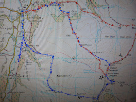
Snow fell locally saturday so i headed for the Berwyn's on monday,not the best day for photography with the skies being leaden but i was hopeful the summit's would be clear.Parking at Llandrillo i headed up the green lane,the 4x4's must have been out recently as the lane was very rutted on the ascent.
Crossing the 2 ford's i turned right at the crossroad's and headed up Moel-Ty-Uchaf to visit it's stone circle.
Re-tracing my step's back to the lane my route took me between the un-named 548 metre top and Moel Pearce and onto Trawsnant.The decent surface of the lane gives way to a rougher surface,rutted by 4x4's and off road biker's and hardened by the recent frost's.
Grassy at first and then turning more heathery as i hit the snow line and my first view of Cadair Bronwen.
At Trawsnant this lane continues to Bwlch Maen Gwynedd but i took the short cut on the minor path that follow's the fence straight up to the summit.Luckily the boggy ground was frozen so no need to do the usual Berwyn bog trot,zig-zagging around,that was to come on the descent.
Looking across to to Cadair Berwyn and Moel Sych.
The wind started to strengthen as i gained height,the last few steep metres a real struggle to stay upright.I eventually reached the stile and crossed it quickly to take a few photo's of the summit marker's atop Cadair Bronwen.
I have never known a winter like it for high wind's in the mountain's and today was no exception,leaving the summit i headed down to Bwlch Maen Gwynedd carefully,it was very slippery on and off the duck board's.
At the bwlch i took a detour to visit the standing stone between Tomle and Cadair Berwyn,this stone was re-erected by "High Sports" in 2008.Below you can just see the stone on the horizon left of centre at the end of this rutted footpath.Here i was sheltered from the high wind thankfully.
My trekking poles resting against the stone to show it's height.
Great view of Craig Berwyn from here.
Re-joining the main path from Cadair Bronwen i was once more exposed to the ferocious wind.It was blowing right to left and trying hard to force me off the cliff's which were to my left,it was a real struggle to stay away from the edge.I eventually reached the trig point and struggled to take a few photo's.
200 metres south of the trig point and 10 feet higher is the north top of Cadair Berwyn but i didn't visit this summit due to the high wind's,i just wanted to get off this summit as quickly as possible.Heading west over the stile i made my way down Foel Fawr,the wind easing as i quickly lost height.Below looking down on Pennant.
Below the snow line the thaw had set in and it was a boggy descent all the way back to Llandrillo.On my map i saw there was a cairn on Pennant so made a small detour off the path to visit it,i was impressed by the size of it.
My route now was to cross the Nant Cwm Tywyll,seen below,and head across to the Afon Clochnant.At least i was sheltered from the wind here and was able to take my hat and coat off.
The camera stayed away as this was the most boggiest section on the walk.I had to zig-zag up and down in a few places to cross the small stream's below Carnedd y Ci,in fact the whole area was just like a giant wet sponge.I was so glad when i reached the decent track above Blaen-y-dre.
At the fork i took the left hand lane,as i had walked the right hand lane previously.
Some impressive sheep in the field's.
Dropping down into Llandrillo i walked past the impressive Llandrillo Hall and back to the car park.Today's walk was 11.5 mile in length with 2,900 feet of ascent.
MILEAGE 86
ASCENT 20,050
TOPS 23.


No comments:
Post a Comment