FOEL FRAS SUMMIT.

FOEL FRAS SUMMIT.

Tuesday 31 January 2012

#7.LLANTYSILIO MOUNTAINS from the PONDEROSA.31-1-12.


A short walk today starting from the Ponderosa and taking in the 4 top's of the Llantysilio Mountain's.The temperature was minus 2 degree's celcius and misty as i left the car with a little bit of snow on the ground.

It only took me 15 minutes to reach the unmarked summit of Moel y Faen seen below.

Next up was Moel y Gamelin about 1 mile away which i reached in 20 minutes.The high point today at 1,983 feet tall.

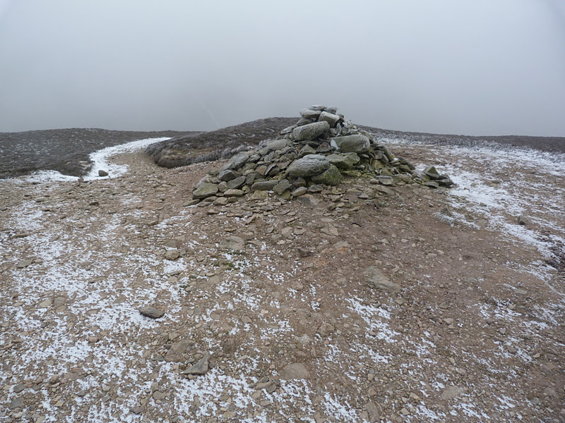
Not hanging around at the summit as the view's were non existant and it was bitterly cold in the wind i set off to Moel y Gaer,seen below,down the horrible scree slope made worse today with the snow and ice.I reached the summit in 20 minutes.

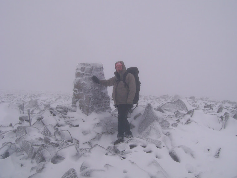
Next up is the fourth summit of Moel Morfydd which i reached in 15 minutes.It had only taken me 1 hour and 10 minutes to reach the trig point on Moel Morfydd,a distance of 2.7 miles but a quick time considering the condition's.

I retraced my step's over the iron age hillfort of Moel y Gaer to the bwlch where the Clwydian Way crosses it,seen below.

I now headed north contouring below Gribin Oernant and came across this old car seat at the side of the path.

On reaching the boundary wall of the Plas-yn-Rhos farm i headed east past the disused quarry.

Leaving the field i reached the minor road near Plas Norway.

This left me with a 1 mile walk back to my car.A distance of 6 mile was walked with 1,800 feet of ascent.


MILEAGE    54
ASCENT      11,550
TOP              18.

Monday 30 January 2012

#6.DOVEDALE VALLEY,DERBYSHIRE.29-1-12.


A walking forum meet was arranged and as Julie was feeling a little bit better we added our names to attend and we met the other 29 member's in the village of Thorpe.A lot of people that we hadn't previously met were in attendance as well as some very good friend's that we have known for a long time.Micky was leading the walk and we set off on a very cold,dank dreary day.

We soon left the village and were out into the field's and our first view of Thorpe Cloud,right.

Overnight there had been a heavy frost and with the temperature rising slightly the ground had softened and with the field's being muddy the mud was sticking to our boot's in big lump's.

Below the entrance to the Dovedale valley with Thorpe Cloud right and Bunster Hill left.

Back onto the road we crossed over the River Dove and left Derbyshire and entered Staffordshire.

Back into more muddy field's with a good view to a distant Thorpe Cloud.


There now involved a steep slippery pull up to a col on the side of Bunster Hill and the group started to spread out.Below is some of the group taking a breather at the col.

The village of Ilam.

Leaving the col we hit a very tricky traverse on exposed slippery limestone and a very muddy path.A few of the females were struggling but the male member's helped them out and eventually we all got over it.

More cloying muddy field's led to a short stretch of road work before we went into another stretch of muddy field's before we eventually reached the village of Wetton were we had our dinner break.We passed the "Old Police House" which had some stock's in the front garden,Howie couldn't resist trying them out.

There is a lot of dry stone wall's in the area with narrow gap's for the footpath's to pass through,every time the group reached one there became a long wait as we all squeezed through.

The next village we past through was Alstonefield and it's little Well.


A few member's decided to have a pint in the local pub and as the group were not going through the Dovedale Valley me,Julie and Howie left them and walked through this delightful valley following the River Dove.On our way to Milldale we saw a hot air balloon hovering low over the misty valley.


Milldale bridge.

Below are a series of photo's along the river path that we followed for 3 miles back to the foot of Thorpe Cloud.


Howie had been feeling unwell all day but had worsened in the last hour so he took the shortened route along the Lin Valley back to the car whilst me and Julie ascended the shapely Thorpe Cloud.


A slippery descent down to the Lin Valley and a short walk back to Thorpe were we arrived at the same time as the other's.We drove to the village of Fenny Bentley for a drink before Howie drove us home.We walked a distance of 12 miles with 2,100 feet of ascent.

MILEAGE     48
ASCENT      9,760
TOPS           14.

Tuesday 24 January 2012

#5.LLANDEGLA VILLAGE.23-1-12.


No walking again this weekend as Julie hasn't shaken off her cold and is still suffering with her eye infection and didn't feel well enough to get out,so as i was on my day's off on monday and tuesday i had a quick look at the weather to see if i could get out,tuesday's forecast was for rain most of the day and monday's was for a dry start,low cloud with patchy rain,so i choose a low level walk and decided to go on the monday.I had noticed a walk starting in Llandegla on the BBC walking website and noticed that somebody had hidden 15 geo-caches on the route so i decided on this walk.I parked across the road from the church and set off on the Offa's Dyke LDFP.


I had walked this section 3 year's ago with Julie when we were in training for our 8 day walk on the southern section of the dyke and was familiar with it.The path follow's the Afon Alyn as it gain's a little height.

The caches were coming thick and fast so i wasn't taking many photo's.The path leaves the river just before it crosses the B5431 near the caves in the limestone ridges.Charles Darwen passed through here in 1831 when he was studying the rock's of North Wales and his friend Professor Boyd Dawkins excavated these caves in the mid 1800's and discovered a burial site of people who lived and farmed here 4500 year's ago.Detouring from the route i visited the minor top of Moel y Waun and it's trig point which stand's at a height of 1,351 feet (412 metres) and it gave me a good view over to the Llantisilio Hill's.

In the other direction the Offa's Dyke path goes over Boncyn y Waen-grogen on it's way to the Clwydian Hill's and Moel Famau seen below.

A bit of road work now entailed before the walk passes a series of limestone fan shaped ridges on it's way back to the village.

After passing some frisky sheep i again made a detour off the path to visit the Ffynnon Tecla (Tegla's Well) that Llandegla is famous for.


I washed my boot's in the Afon Alyn before returning to the car just as the rain started.

Found 16 caches on route and walked 5.5 mile with 700 feet of ascent.

MILEAGE     36
ASCENT       7,650
TOPS            13.