FOEL FRAS SUMMIT.

FOEL FRAS SUMMIT.

Monday 28 February 2011

#15.Tal y Fan from the Sychnant Pass.24-2-11.

Feeling better after our bout of flu and with a good weather forecast i decided to take Julie to the Northern Carneddau and walk the most northern Nuttall Tal y Fan which stand's at a height of 2,001 feet.The whole of the northern Carneddau is scattered with relic's of Bronze Age and Iron Age occupation with standing stone's,hut circle's and burial chamber's.
            We drove up the A55 and got caught in some very heavy traffic due to road work's to eventually reach Conwy,we drove through the "Upper Gate" in the town wall's and headed up to the top of the Sychnant Pass driving past the high stone wall's of the Pen Sychnant Estate.Before the railway was built the mail coaches use to come this way whenever the tide was in and they couldn't use the quicker coastal route.
           The view's are great from the top of the pass,this is looking down to the coast.

Crossing the road the path take's you under Craigyfedwen.Looking back to Alltwen.

and to Mynydd y Dref (Conwy Mountain) and it's hill fort Castell Caer Seion.

The path get's quite narrow in places with big drop's down to the Afon Gyrach.

Our first glimpse of Tal y Fan 3 mile away and the Gyrach deep valley below.

The path run's to this small house above the valley,there are no road's to it,the owner's have to drive across the field's in their Landrover!

We must have passed 100 Carneddau Ponies on this walk,we have never seen so many on a walk.

We came across this little lake,Llyn y Wrach (the witches lake) where we had a break whilst i went to find the geocache hidden nearby.

It was very warm in the sunshine and i think Julie is having a nap.

The first stone circle we came across today.

Looking down the Gyffin valley toward's Conwy.

Close up of Conwy Castle.

We followed a decent track up to the quarry on the north east side of Tal y Fan and found our first standing stone.

Couldn't resist a "facedown" on it.

We entered the quarry where i left Julie sitting in the sun whilst i went to find the hidden geocache.I spent 15 minute's trying but failed so i walked back to the edge and called down to Julie,"come and help me".

Julie asked me to read her the clue and within second's she had found it,in this tunnel.

We left the quarry for the last climb up Tal y Fan,looking back to Llandudno and the Great Orme.

We reached the wall that run's to the summit.

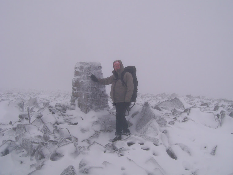
At last the summit of Tal y Fan.

We dropped down to the bwlch between Tal y Fan and Foel Lwyd,seen here with Drosgl in background.

Some nice gentle walking now ensued taking us north.

We headed for a small hill called Moelfre,seen here.

There was a geocache hidden here,Bachelor's Baby,named after a plane that crashed here,so Julie grabbed a break whilst i went to find it.

The crash site.


We contoured around Moelfre to pick up the North Wales LDP.

The ponies had found a good spot to graze.


The Druid's stone circle above us.

Another standing stone with Tal y Fan in the distance.

We crossed this little bridge across the Afon Gyrach.

Only 1 mile back to the car now.

Above Penfforddgoch.


The homeward straight.


Back to the car park.

Today we walked 9.5 mile's with 2,050 feet of ascent.


MILES       99
ASCENT   25,600
TOPS         30.

Tuesday 15 February 2011

#14.Cadair Bronwyn,Wayfarer's Memorial.14-2-11.

I have walked in this area quite a few time's so was delighted when my friend's asked me if i was available to lead a walk from Llandrillo up into the Berwyn's.My friend's,Howie,Clive,Sampo and his spaniel Molly met at  my house at 09.45 a.m. and we arrived at Llandrillo at 10.30 and parked in the village car park near the Ceidiog river.Llandrillo is named after St. Trillo who came to Wales from Brittany and built the church on a mound near the river.

It was a nice sunny morning but was quite cold,the forecast was for possible snow shower's on the higher ground in between sunny period's.
     We joined the Green lane that run's from Llandrillo to the village of Pentre in the Ceiriog Valley.It lead's steeply up into the Berwyn.

This lane is regularly used by off road vehicle's and is quite badly eroded and after the recent heavy rain was difficult to ascend and we had to walk slightly off piste on the grassy area.

It was quite warm whilst we were on the lane but when we had gained some height and hit the open ground and made for the stone circle,Moel Ty Uchaf,we realised how cold it was,from the car park we had gained 900 feet whilst walking 1.7 mile.After taking a few photo's near the stone circle we noticed that some poor weather was heading our way and we got our wet gear on.
The boy's ascending.


This is the view to Cadair Bronwyn before the snow hit us,Moel Pearce above the conifer tree's.

We had just crossed Moel Pearce when the first snow storm hit us.Howie and Sampo pictured here.

The snow persisted for the next hour,been driven by the high wind which hampered our progress.We reached the sleeper path at Bwlch Maen Gwynedd as the snow stopped.These sleeper's are layed down on a blanket bog to protect it.This pass between Cadair Bronwen and Cadair Berwyn is known as Ffordd Gam Elin (Helen's crooked road) and is said to be a Roman road and is named after Elen,a Welsh princess who married a Roman emperor.

After 5 mile of walking we hit the summit of Cadair Bronwyn which stand's 2,575 feet high,pictured here.It's summit beehive cairn is called Bwrdd Arthur,it is the highest point in the Unitary Authority of Wrexham (county top).


Dropping down to Cwm-llawenog we soon reached the summit of Cadair Bronwyn North East Top seen here with a height of 2,297.The area is boggy with cotton grass and heather.

Below is a view to the mountain Pen Bwlch Llandrillo and below it lies the Wayfarer's Memorial.There used to be a large shed here,it's only use appear's to be for shelter from the element's for visitor's.

From here we dropped down to the Wayfarer's Memorial,see link.

www.tracks.me.uk/wayfarer.html

It stand's at the highest point on the pass at an elevation of 1,950 feet.


We re-joined the green lane for the 4 mile walk back to the car.Being sheltered by the mountain it was quite warm in the sunshine.We could see all the way to Snowdonia and it's mountain's were covered in snow.


The weather was very changeable,one minute sunny the next snowing.

We stopped for a break by the Maureen Stone bench.

The nearby Afon Llynor which flow's from it's source high up in Hen Dwr.


Which flow's under the little stone bridge of Pont Rhyd-yr-Hydd.


Looking back up to the Wayfarer's ,Memorial.

Approaching Coed Gerynant and the ford and another snow shower on the way back to the car.                                                                                           

Nearing Llandrillo.

The walk was 10.5 mile's in length with 2,700 feet of ascent.
MILES     89.5
ASCENT    23.550
TOPS    29.