FOEL FRAS SUMMIT.

FOEL FRAS SUMMIT.

Friday 21 October 2011

#55.KENTMERE WALK.20-10-11.

A trip to the Lake District was organised and saw me,Howie and Killy meeting Micky in the beautiful village of Kentmere.We parked near the church on a very frosty,freezing cold but sunny morning.


We left the village walking past "The Nook" and below Ewe Crags heading up the Garburn Pass.It was like walking on a dried up river bed,a horrible ascent over loose stone.

At the top of the pass we got a distant view across to Raven Crag and Red Screes.

And down to a cloud inversion over Windermere.

We now turned right and the path ran below Buck Crag on it's way to Yoke.It was very warm now in the sun but the cloud's were rolling in from the coast and looked like they were bringing rain with them.At least the path improved.

 Summit pose.

The cloud quickly reached us bringing some light drizzle and low cloud so we donned our wet gear as we left the summit.It is a short walk to the next mountain Ill Bell and we were soon at it's summit.


A long way below us lay the Kentmere Reservoir.The cloud blurring the view.

Next up was our third Nuttall,Froswick,again a short walk away.The rain had stopped and the cloud was dispersing.


A happy chappy at the summit of Froswick.

We headed for the course of the old Roman road on our way to Thornthwaite Crag in ever improving weather.


Just as we reached the impressive beacon that mark's the summit it started to cloud over again.

After having dinner here we headed for High Street about 1 mile away.


Micky suggested walking over Mardale Ill Bell and the Nan Bield Pass but i wanted to follow the route i had in my GPS and out of the Nuttall's Book that took in Rough Crag and after much debate we headed for Rough Crag as the weather worsened,the rain getting quite heavy and low cloud again descending upon us.
So we dropped down Riggindale Crag to pick up Rough Crag.


The plan was to walk down to Blea Water,pictured below.

But i was over-ruled and the gang decided to walk down Dudderwick to reach Haweswater Reservoir.

The Rigg.

Here we then walked up the steep path to the top of Gatescarth Pass where we should have ascended Harter Fell but again the group didn't fancy it and the decision was made to walk down the Long Sleddale Valley.

Although the rain had stopped a very cold wind was blowing up the valley into our faces.This 2 mile trek was down on the worst terrain of the day,horrible inverted stones layed for a track and very wet with the recent rain.I slipped on a section and really hurt my knee,i was not a happy bunny.Although it's a beautiful valley i did not enjoy walking it.

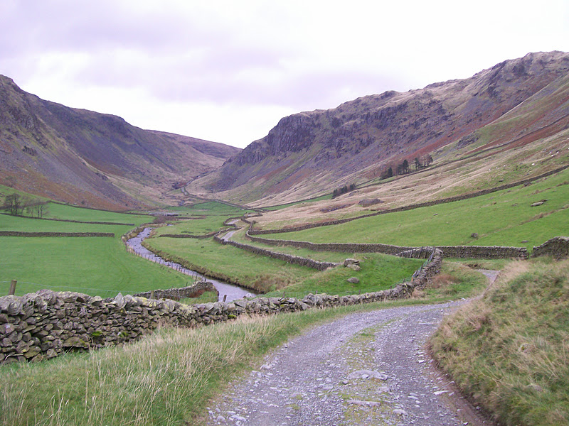
Eventually we reached Sadgill and crossed the River Sprint and took the path behind this farm.


2 mile later we arrived at Stile End to eventually reach Kentmere and a great view back up the valley.Today's walk was 15 miles long with 5,000 feet of ascent taking in 6 top's.


MILEAGE  393.5
ASCENT 96,800
TOPS       95


Tuesday 18 October 2011

#54.SHROPSHIRE HILL'S.15-10-11.

A walking forum meet up was held in the Shropshire Hill's and present were me,Julie,Julian,Deb,PistonPete,Sue,Howie,Lovinit,Sharon,Mike and Brian.We met just outside the village of Ditton's Prior and headed into Stanbrough Wood.

On leaving the wood we turned left up the tarmac path that lead's to the wireless station on top of Abdon Burf first passing an old Dolerite mill.


The highest point in Shropshire.

We then headed for the Shropshire Way LDFP which dropped down to Five Spring's.


Passing a memorial to the 23 airmen who died on the Brown Clee Hill's.

We then dropped down to Cockshutford and it's tiny church.

And a memorial in somebodies back garden.

Next we headed steeply up to Nordy Bank Iron Age Hillfort.

The rampart's enclose an area approx. 250 metres by 200 metres,one of the biggest i've ever seen.

We headed across Clee Common to have our break by the Navigational Station above the disused quarry.

Dropping down into Castle Covert we walked past Boyne Water.

The next part of the walk was through some ancient woodland,some majestic tree's interspersed with young sapling's that had been planted.


Sue had spotted some giant cones and wanted one so Mike climbed the tree and made a grab for one of the cones and as he touched it it disintegrated showering him with hundred's of seed's,man it was funny.

Taking another break by the delightful Bridge Pool......

......before taking the lane back to the car,s with some lovely distant view's.

We stopped at the Howard Arm's in Ditton Prior's before me and Julie drove to our b+b in Bridgnorth.This lovely walk was 10.5 miles long with 1,800 feet of ascent.


MILEAGE       378.5
ASCENT        91,800
TOPS             89.

#53.MYNYDD MAWR.14-10-11.

Day 3 of our Snowdonia jaunt saw me and Micky parking at Rhyd Ddu on an grey overcast morning.We took the forest track above Llyn Cwellyn

On leaving the forest we started to gain height quickly on the steep eastern flank of the mountain.

I have noticed an breached dam below Clogwynygarreg that needed investigating so i suggested we take a detour on our return,below,the dam wall.

We now headed up the path that rises above the cliff's of Craig y Bera.

You get a fantastic view from the top of the cliff's down the Nantlle Valley and across to the Nantlle Ridge.

It was a lot colder today than the other 2 day's and we could tell it was raining on the Nantlle Ridge,we had a few spot's but not heavy enough for us to put our coat's on.Anglesey was basking in sunshine as we reached the 3 stone shelter's at the summit.Here we grabbed a quick break but didn't linger,gloves and hat were put on to keep out the cold.

We retraced our step's to the forest edge,taking our time as the path is littered with loose stone and pieces of slate poking out the ground and it was very slippery.Below is the view down to Clogwynygarreg and the breached dam.


The breached dam.


Ruined building with view down the Nantlle Valley.

The path then bring's you to the beautiful Llyn y Dywarchen.


Clogwynygarreg in the foreground with Craig y Bera in the distance.

This grand little walk was 5.5 miles in length with 2,000 feet of ascent.


MILEAGE         368
ASCENT          90,000
TOPS               89.