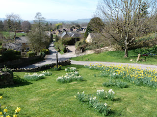
As me and Julie were having a 4 day break in the Cotwold's i phoned Brian (Cotswolds Stroller) to see if he fancied meeting up for a walk so he organised a meet up to see if anybody else fancied meeting up and Alan,Paul and Fiona joined us in Snowshill for a lovey walk on a glorious sunny,warm day.Starting from the Snowshill Arms we headed off across field's to Lidcombe Wood.
Leaving the wood we walked along the B4077 for a short stretch before picking up the Cotswolds Way and passing through this prnate kissing gate.
Next we passed Stanway House,seen below.
The Jacobean Gatehouse built around 1630.
We grabbed a quick break before pressing on to Stanton where we took a detour to have a cider in the Mount Inn,which has a great view over the Vale of Evesham,seen below.
Leaving the village we passed the stables and paddocks which were a hive of activity on this sunny day before eventually reaching Laverton.
A short walk to the next beautiful village of Buckland.
The route back to Snowshill was pleasant,at first on a track and then across field's to round off a great walk.
Today's walk was 8.5 mile long with 1,300 feet of ascent.
MILEAGE 137
ASCENT 34,600
TOPS 39.
FOEL FRAS SUMMIT.
Wednesday 28 March 2012
#19.SENIORS RIDGE,GRIBIN and TRYFAN.23-3-12.
I met Glyno at Northop and he drove us to the Ogwen Valley where we met Julian for a day of scrambling in the Glyderau.Starting at the large lay by we walked down the road to Ogwen Cottage and took the path that lead's into Cwm Idwal.We walked to the left of the lake and about two third's of the length of it located a faint path that rose steeply into the Nameless Cwm,in just over 1 mile we rose about 1,000 feet and we took our top layer off as it was a glorious sunny day,if a bit hazy.
In the Cwm we walked across to the bottom of Senior's Ridge and started to climb.After 10 minutes we looked below and spotted a lone walker with a collie dog,he was wearing short's,a t-shirt,trainer's and had no bag.He made his way to the foot of the Cneifion Arete and started to climb it.His dog took an easier route for a few hundred feet and met up with him higher up and then they both climbed together and did the whole Arete in under 15 minutes,it was amazing to watch.We carried on scrambling up the ridge with Julian taking a harder route then when he last did it and me and Glyno following,it was a great scramble on very friendly rock.Below is the start of the scramble.
Posing on the way up.
Just over a 1,000 foot scramble we reached level ground a short distance away from the summit of Glyder Fawr.Below the boy's look down on Cwm Idwal.
A quick visit to the summit and we then set off to descend down the Gribin.
We walked over to the top of Cneifion Arete to have a look down.
Losing 1,300 feet in a mile we were soon by the shore of Llyn Bochlwyd.
We now walked up to Bwlch Tryfan where we had our dinner.Suitably replenished we set off up the south ridge of Tryfan for my 33rd visit to it's summit.I could of sat at the summit for hour's,there was no breeze,it was very quiet with not another soul there and very warm in the sun.After taking a few photo's we set off down the west face descending 2,000 feet in just 1 mile.Today's walk was 6.5 mile long with 3,750 feet of ascent.
MILEAGE 128.5
ASCENT 33,300
TOPS 38.
Monday 19 March 2012
#18.BARBER'S HILL aka GERAINT'S HILL.19-3-12.
A short walk today to see how Julie get's on with her Plantar Fasciitis.Parking in the main car park in Llangollen on a very sunny day we crossed the A5 and took the footpath up through the tree's on our left.
This rises steeply up to the road near the thatched cottage.
We followed the road up to the next junction and turned right and got a glimpse of Castell Dinas Bran across the valley.
Leaving the road we took a path that rises above a small quarry.
We now left the tree's and were out into a field riddled with rabbit holes and absolutely smithing with load's of rabbit's,which fled in all direction's when they saw us approaching.The mast was soon reached.
At the summit we had a great view to the Llantysilio Mountain's.
Following the access track away from the mast we crossed the bridle path to follow a footpath in the direction of Bache Ganol.
This lead steeply uphill into a field with a view back to the mast.
Picking up another bridle path we headed down toward's Llangollen.
We crossed town for a visit to Plas Newydd's garden's.
This super little walk was 4 miles long with 1,100 feet of ascent.
MILEAGE 122
ASCENT 29,550
TOPS 35.
#17.GWRYCH CASTLE and LADY EMILY'S TOWER.18-3-12.
Today i travelled up to the village of Rhyd-y-foel with Clive and Howie on a sunny morning with quite a sharp wind to visit an area that i haven't been to before.The boy's let me lead and we first visited the hillfort of Pen-y-corddyn-mawr after trying out the local swing first.
We soon got our first glimpse of the hillfort through the tree's.
The path lead's to the south of the hill,affording us a fine view of it's west side.
We soon reached it's plateau and walked to the northern edge for a view toward's the coast.
Summit marker with Cefn yr Ogof,our next hill,in the distance.
Dropping down to the lane we followed this for a short distance before turning left toward's the Henblas Farm.We then entered the field's and walked the short distance up to the trig point with a fine view across to the Great Orme.
Lady Emily's Tower lies directly north but in between us lies a small plantation of pine tree's.There was an obvious path through so we followed this.
Obviously walked regularly this lead us straight to the path a short distance from the tower.
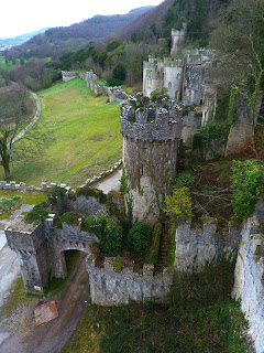
The view from the tower is amazing,but i didn't like looking out of the north window downward's,the tower is built right on the edge of a very steep cliff,it turned my stomach.Following the path east through the tree's we headed off to visit Gwrych Castle.Dropping down to it's west tower it gave us a fine view of it.
We dropped down behind the castle hoping to find a path going round the back of it but we encountered a fence,not wanting to retrace our step's we climbed steeply up a bank to locate the proper path that skirt's the castle.We dropped down onto the road in front of the castle and made our way back to our car.
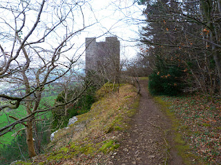
This road eventually run's into a track that contour's below the tower,seen below.
We reached a point where the path split's,i knew the left path would lead back up to Cefn yr Ogof so we took the right hand path hoping to find a way out onto the A457 as it stayed low.We reached the gate house and farm but couldn't find a way out through the farm so walked along the field following the wall until we reached a section that was low enough to climb over.We followed the A457 back to the gate house,seen below.
We then walked the short distance back to the village and our car.Today's distance walked was 5.5 mile with an ascent of 1,450 feet.
MILEAGE 118
ASCENT 28,450
TOPS 35.
Subscribe to:
Posts (Atom)


