FOEL FRAS SUMMIT.

FOEL FRAS SUMMIT.

Tuesday 22 November 2011

#60.MOEL FAMAU,MOEL FENLLI Linear walk.21-11-11.

Today's walk saw me walking locally in the Clwydian Mountain's.Meeting Howie at the Clwyd Gate Motel at 9a.m. i arrived a little bit early at 8.30 so got my boot's and gaitor's on and waited for him.Luckily Howie was early arriving at 8.50 so i left my car there and jumped in his for the short drive to the village of Cilcain where we left his car by the water pumping station and we were walking by 9 o'clock.We took the lane that lead's up to the 3 reservoir's.

We took the second left turn to walk past the Cae Newydd Farm.

At the next junction we carried straight on in the direction of the Anderson Shelter.


The Anderson shelter was a decoy site to protect the Valley Works in Rhydymwyn,i found this following text about the site.......
During the beginning of the Second World War hundreds of these sites were built and there were many different types and designs. In 1941 it was decided that Valley Works needed a night type decoy known as a QF site to draw away any enemy aircraft.

The control bunker for the site was an Anderson shelter with blast walls screening its entrance. There was a steel ladder on the far wall which led to an observation hole in the ceiling which was probably enclosed as a wooden sentry box. This bunker was the control centre to ignite fires on Ffrith Mountain running up to Moel Famau. The actual fires were located in combinations of troughs and baskets filled with flammable material, some capped by tar or roofing felt and fed by fuel from distant elevated storage tanks. They were ignited from the bunker by a series of detonators set in the troughs. If you look closely on the side of the trail on the way to the bunker you might see the detonator cables.

When the site first opened it was manned by RAF personnel and later manned by Valley staff or local police. There was also no phone at the bunker in its early days the nearest phone was around 1½ Miles away, someone would have to cycle to the phone to receive orders and information about possible incoming enemy aircraft. A phone line was installed later on and there’s evidence of this near the door.

The Valley site was never detected by enemy aircraft and was the only UK military site to remain unknown during the war.


Taking the lane that run's below Ffrith Mountain now,rough at first.


And then nice and grassy,we soon got our first glimpse of the Jubilee Tower.


We took the short cut through the forest.


To reach the rough track just short of the summit of Moel Famau.


Looking back down to Cilcain and the forest we walked through from the tower.


The weather was a real bonus,the forecast's i saw was for a dull cloudy day with the chance of rain and although it was a little bit cold we had some decent spell's of sunshine and it was quite warm when we were sheltered from the wind.Heading down the main path now to Bwlch Penbarras car park we had a little altercation with 2 ladies who had 7 dog's off their lead's,1 of them chased some sheep over the shoulder of the mountain,and they were quite put out when they were told that the dog should of been on a lead.If i had a phone number for someone in authority i would have rang them to tell them about this dog.Below is the bwlch car park and Moel Fenlli.


There are 2 way's up Moel Fenlli,a very steep attack up it's north face which bring's you directly to the summit or the gentler westerly approach following the Offa's Dyke footpath with great view's over the Vale of Clwyd,we chose the latter.


The hill fort has large ramparts on all sides and a portal on the west side,here is Howie entering it.


Here you turn right and follow the ramparts south.


Eventually reaching the steep stepped path up to the summit.


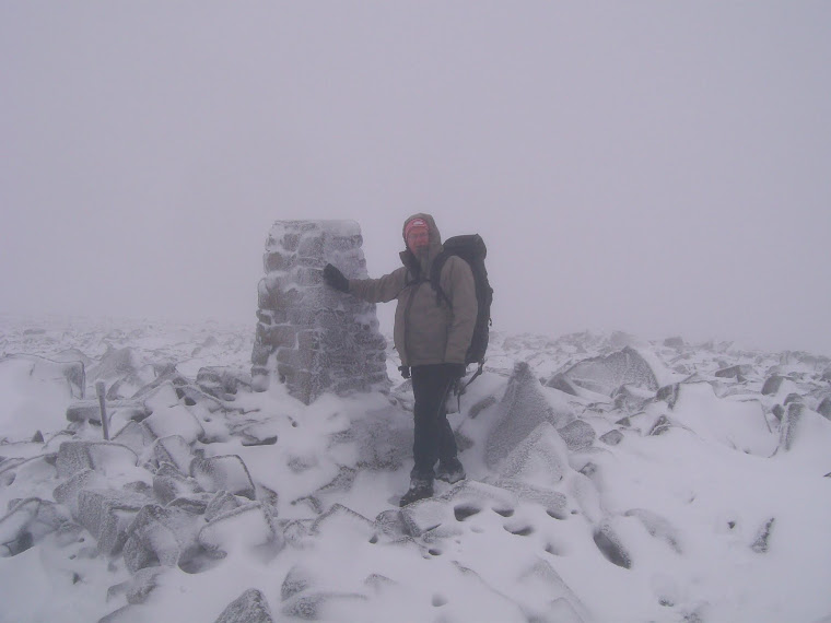
Me at the summit with Moel Famau in the distance.The mountain is named after the British King Benlli who ruled this part of Wales in the 5th century.


Close up of Moel Famau.


Heading down to Fron-heulog we still had time for a detour to pick up a few small hill's that had been on our to-do list for a while,so we headed for the tumulus above the Cae Mawr Farm seen below.


From here we had a good view back to Moel Fenlli.


The cloud's started to roll in and it looked like they were carrying rain so we made for the track below Moel Eithinen and headed for Gyrn.


Close up of the mock castle with Moel Gwy in the distance.


Howie descending Gyrn.


We just made it to the car as the first spot's of rain started to fall and we then drove to the Druid in Llanferres for a pint.Within minutes the cloud had dropped down very low and you couldn't see any of the hill's,how's that for timing.This great little traverse was 7 mile long with 2,150 feet of ascent.


MILEAGE      429.5
ASCENT       106,300
TOPS           105.

Monday 14 November 2011

#59.ARENIG FAWR REMEMBRANCE SUNDAY.13-11-11.

It's been on my to-do list to visit the summit of Arenig Fawr on remembrance sunday for a few year's now and this was the day i knocked it off.The weather all week had been poor in Wrexham,leaden skies,rain and drizzle but the forecaster's had predicted a nice weekend.I had a lazy day on saturday after getting up off night's and was raring to go on sunday,particularly as the forecast was for a clear,sunny day with reasonably strong wind's.We rose at 6a.m. and were leaving the house at 7.It was a lovely sunny morning on the drive there but it soon got cloudy.We parked at Pont Rhyd-y-fen where we alway's leave our car near to the dis-used Wrexham to Barmouth railway line and were walking at 8a.m. I had decided to take Julie to see the bothy by Llyn Arenig fawr so this entailed a 1.5 mile walk along the old road through the village of Arenig.

The old chapel.

Looking across to Arenig Fach low cloud had started to descend.

It was very warm walking along the road but as we turned onto the track that lead's to Llyn Arenig fawr and started to gain height it was getting windier so we stopped to put our fleece's and hat/ear warmer's on as it was a cold wind.

I deliberately set off early with the intention of having a brew in the bothy and to have a slow steady walk up to the summit of Moel yr Eglwys (AKA Arenig Fawr) but on reaching the bothy that was out of the question as a noisy group were surrounding it.

So we crossed the ladder bridge and found a spot a little higher up out of the wind and away from the noise.

Looking up the cloud's had really come down but it was brighter further east and i hoped it would clear before we reached the summit.

Reaching the cliff's of Y Castell the wind was gaining in strength making the going tough but i knew we had load's of time to get to the summit for 11.11a.m. so we took our time over the tricky rocky terrain.

We got no view of the summit,as it was a pea-souper,until we were about 20 metres away.We had timed it to perfection as it was 11 o'clock when we arrived.Although we had only walked 4.5 miles it had took us 3 hour's but we were taking our time,we didn't want to make the summit too early and stand around in the cold for too long.I was very surprised to only see 4 other people on the summit,perhap's the weather had put other's off.There were a few poppies at the memorial plaque to the 8 man crew of the Flying Fortress that crashed on August 4th 1943.

Julie paying her respect's by the memorial on the 2,802 foot summit.

It is only a quarter of a mile to Arenig Fawr South Top,another Nuttall,but in the strengthening wind which was blowing from the east crossing it's rocky summit was not an easy undertaking,great care was needed not to have an injury on the rock's.Julie near the 2,743 foot summit.

Heading south and descending the mountain the terrain get's very rocky so i had to take the trekking poles off Julie so she could hold the fence on the descent as the rock's were very slippery.Just as we reached the grassier part of the descent the cloud's started to lift,giving us faint view's at first and then the cloud disappeared all together affording us tremendous view's.The wind was still very strong,not as bad as our last walk on Llwytmor but not far off.


Finally a view to Moel Llyfnant.

The descent flatten's out to an area of small lakes and knoll's and in half a mile the summit of Arenig Fawr South Ridge Top (2,336) is soon reached.


My intention was to carry on south along the ridge to Craig y Bychau and cross to reach the south end of Moel Llyfnant and to search out the old mine working's on the ascent,but as it was horrendously windy i changed our plan's and we dropped down to the fence and crossed it to descend to an old wall where we took a break.we were sheltered from the wind on this side of the mountain and sitting in the sun it was very warm.Below,Julie admiring the view with Moel Llyfnant across the valley.

Crossing the boggy col we started our last big climb of the day and were soon getting buffeted by the strong wind's again.The cloud had been lingering on Moel yr Eglwys all day but as i glanced across she was now free of cloud.

Moel Llyfnant summit cairn with Moel yr Eglwys yonder.

The last time i descended this mountain i kept right and there was a tricky section of rock's that had to be negotiated so i headed further left and it was grassy all the way down to the track,result.

It is a 2.5 mile walk back to the car first passing the derelict property of Amnodd Bwll.


And Amnodd Wen.

The track here is very boggy until you reach the wall that lead's to to Craig y Hyrddod.

This track lead's down to the railway line and eventually back to the car.

After a quick change we headed to the Bryntirion Pub in Llandderfel for a sunday roast and a couple of pint's of Bragdy Conwy's fine ale.


The length of today's walk was 10 mile with 3,000 feet of ascent.


MILEAGE       422.5
ASCENT        104,150
TOPS              103.