Today i travelled up to the village of Rhyd-y-foel with Clive and Howie on a sunny morning with quite a sharp wind to visit an area that i haven't been to before.The boy's let me lead and we first visited the hillfort of Pen-y-corddyn-mawr after trying out the local swing first.
We soon got our first glimpse of the hillfort through the tree's.
The path lead's to the south of the hill,affording us a fine view of it's west side.
We soon reached it's plateau and walked to the northern edge for a view toward's the coast.
Summit marker with Cefn yr Ogof,our next hill,in the distance.
Dropping down to the lane we followed this for a short distance before turning left toward's the Henblas Farm.We then entered the field's and walked the short distance up to the trig point with a fine view across to the Great Orme.
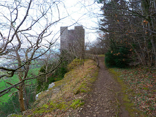
Lady Emily's Tower lies directly north but in between us lies a small plantation of pine tree's.There was an obvious path through so we followed this.
Obviously walked regularly this lead us straight to the path a short distance from the tower.
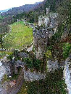
The view from the tower is amazing,but i didn't like looking out of the north window downward's,the tower is built right on the edge of a very steep cliff,it turned my stomach.Following the path east through the tree's we headed off to visit Gwrych Castle.Dropping down to it's west tower it gave us a fine view of it.
We dropped down behind the castle hoping to find a path going round the back of it but we encountered a fence,not wanting to retrace our step's we climbed steeply up a bank to locate the proper path that skirt's the castle.We dropped down onto the road in front of the castle and made our way back to our car.
This road eventually run's into a track that contour's below the tower,seen below.
We reached a point where the path split's,i knew the left path would lead back up to Cefn yr Ogof so we took the right hand path hoping to find a way out onto the A457 as it stayed low.We reached the gate house and farm but couldn't find a way out through the farm so walked along the field following the wall until we reached a section that was low enough to climb over.We followed the A457 back to the gate house,seen below.
We then walked the short distance back to the village and our car.Today's distance walked was 5.5 mile with an ascent of 1,450 feet.
MILEAGE 118
ASCENT 28,450
TOPS 35.


No comments:
Post a Comment